
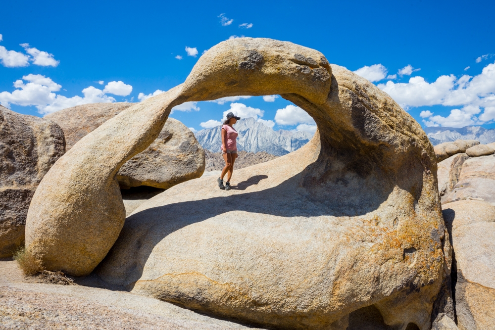
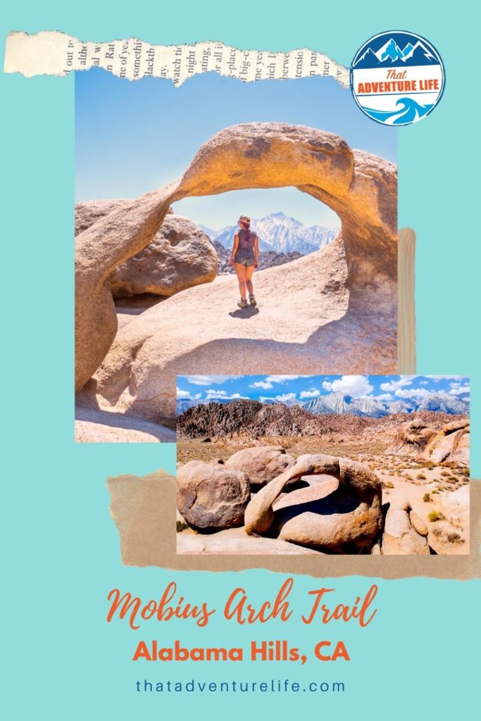
Every time we drive past Lone Pine, CA through U.S. 395, we always have to visit Alabama Hills. This place is A-M-A-Z-I-N-G! It is a desert wonderland full of unique shaped rocks and giant boulders as well as natural arches. Mobius Arch is one of Alabama Hills’ most famous natural arch. The reason for its name is because this large arch resembles a Mobius strip. Not only that, but it also frames Mt. Whitney and the Sierras mountain range perfectly within. This trail is a short loop trail to get to this wonderful spot in the Eastern Sierras.
We love Alabama Hills, we hope you do too. Therefore, please help us protect and keep this area clean and free for generations to come. This means take out ALL your trash, DO NOT deface any rocks, and leave things where they are.
STATS:
Where:
Mobius Arch trailhead:
36°36’41.1″N 118°07’29.4″W
Actual Mobius Arch
36°36’48.9″N 118°07’32.4″W
Fee:
It is free!
Parking:
There is a small dirt lot, right in front of the trailhead.
Restrooms:
There are no restrooms
Distance:
0.6 miles, loop
Elevation Gain:
42 ft
Level:
Easy
Estimated Completion Time:
1 hour
Ideal Weather:
Falls and Springs are best. Alabama Hills area can get VERY warm in the summer.
Ideal Time:
Go early or later in the evening for cooler temperature. Sunsets can be beautiful here though.
Pet-friendly:
You can bring dogs but they have to be on a leash.
Weather:
VIDEO:
THE DRIVE
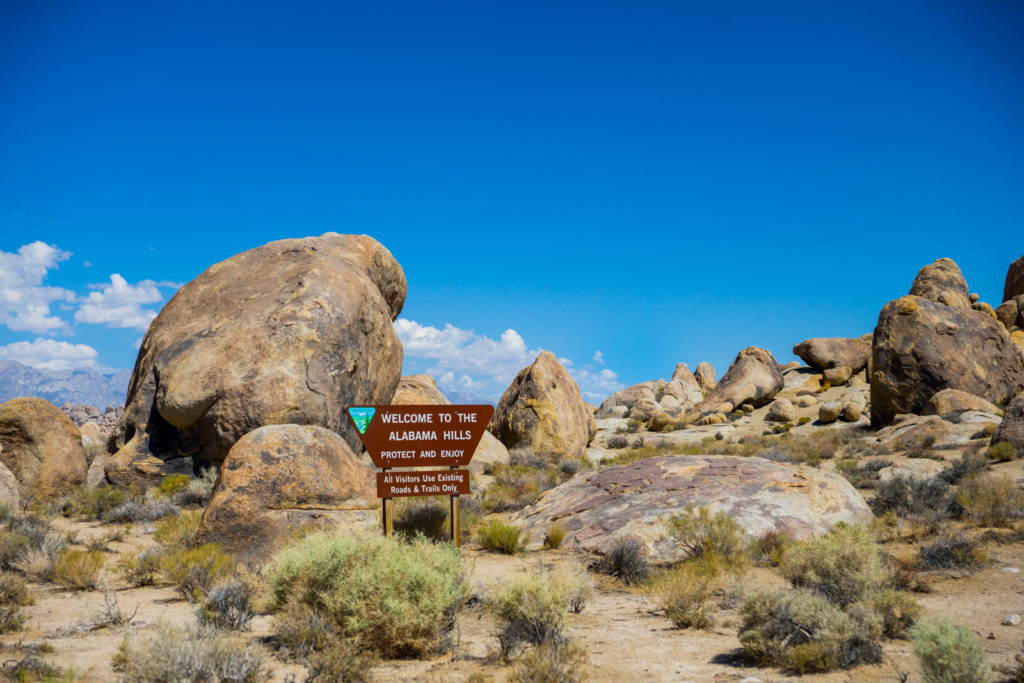
From Lone Pine, CA, follow Whitney Portal Road towards the mountain range. About 2.8 miles, turn right onto Movie Road. Once you’re on Movie Road, there is a sign for Alabama Hills Recreation Area. Besides this sign, the road is otherwise unmarked. You want to stay on the widest dirt road as you go. Make sure to avoid the side roads. As you follow Movie Road for about 1.5 miles, the road splits. Make sure you go right. The parking lot for Mobius Arch is on the left, immediately after this split.
THE ADVENTURE:
Start of the Trail:
We started our hike quite early in the morning. This was in September, but it was still very warm. When we pulled into the dirt parking lot, we were the only car there. This place can get a little busy on the weekends.
The trailhead for Mobius Arch starts at the right end of the dirt parking lot. There is a sign at the trailhead and two lines of small rocks, marking the way. From here, if you look straight across, you can see Heart Arch, hidden next to the big boulders. At the right angle, it looks like a heart, cut out from the top of a small cave. The best view of Heart Arch is actually from the parking lot. Once you get close to it, it doesn’t really resemble a heart at all. You can get to the base of this arch as you hike along Mobius Arch Loop Trail.


After finish admiring the Heart Arch, you can start heading down these neat stone stairs. These stairs lead back up to the trail on the other side. Once you hike up this little hill, follow the trail to the right. After this point, it can get a bit confusing, however, there are usually either stone markings on the side of the trails or small brown signages to show you the way. Since this trail is short and easy, there are many people exploring the area of the trail. Therefore, footprints can be deceiving. Your best bet is to follow the markings on the trail. It is also good if you use your GPS to map out the actual location of the arch (look above for coordinates).
To Mobius Arch:
If you continue on the right trail, you’ll eventually walk past Heart Arch, on your right. Right after Heart Arch, the trail will split to a T. Follow the left to go toward Mobius Arch. You’ll follow this flat stretch for a bit before the trail started to get rocky again. As you make your way through the exposed boulders, Mobius Arch jumps out in front of you as you get closer.


You should be able to climb to Mobius Arch easily front or back. However, the back of the arch is the easiest way to climb up. Besides that interesting shape of the arch, the main reason it is so popular because of its location. If you stand in the right spot, the window of the arch perfectly frames the towering and ominous peaks of Mt. Whitney which happens to be the tallest mountain in the United States. (Note: We should have mentioned it when we first published this article, but the biggest peak you see there is actually Lone Pine peak. Whitney is actually the smaller one off to the right. It looks smaller because it is far back. We noted it in the photo below). The area around here is beautiful as well. We recommend taking to some time to explore the place.


To Lathe Arch and the way back:
Once you’re done here, you can follow the trail on the right of the arch to complete your loop. This area is also home to Lathe Arch. This is a smaller, trickier arch to find, but it also framed Mt Whitney as its backdrop. To find Lathe Arch, from the main trail, walk toward the parking lot for about 100ft or so. This arch is tucked away on the rocky area on the left-hand side. You can see Mobius from Lathe Arch. Because of its angle, it’s hard to see its shape coming from Mobius Arch, however, it is more visible if you come from the parking lot. If you have some time to spare, why not check this one out too!
When you’re ready to head back, follow that main trail, toward the parking lot. It should be an easy way back, minus a couple of small hills. You will be able to see the dirt lot as you get closer.


Alabama Hills is a super awesome spot to stop by on the U.S. 395. Another cool spot on the way is Fossil Falls. If you love public art, check out Olancha Sculptures.
Happy Adventuring. Don’t forget to follow us on Instagram, subscribe to our Youtube channel, and sign up for our newsletter!
RECOMMEND GEAR:
These are the gear that we personally use and find them helpful for this particular adventure. Don’t forget to check out our Recommended Gear section as well.
The majority of these links are through our affiliate links so if you buy something, it is at no extra cost for you but it helps us support the site. That being said, don’t buy something just to support us, buy something if you think it will enhance your travels and adventures.
• Hiking shoes
It’s an easy hike, however, there are some loose rocks and slippery areas. It’s good to wear your hiking shoes. Vy’s shoes are Merrell Women’s Moab 2 Mid Waterproof Hiking Boot. Dustin’s shoes are TARGHEE III WATERPROOF.
• Sunscreen
The trail can get very warm. Bring sunscreen! We use eco-friendly, reef-safe sunscreen, All Good Organic Sunscreen Butter – Zinc Oxide – Coral Reef Safe, and All Good Sport Sunscreen Lotion – Coral Reef Safe (3 oz)(2-Pack) or Stream2Sea SPF 30 Reef Safe Sport Tinted Sunscreen.
• Water
The trail can get very warm! Bring lots of water. Especially if you go in the afternoon. Vy uses the Camelback L.U.X.E. Dustin uses the Clik Small pack (sadly Clik is no longer around). Patagonia Women’s Nine Trails Pack 18L is also a great backpack for a shorter hike like this.
• Good GPS
Alabama Hills has no cell service here. That’s why you need a good GPS device. We use Garmin inReach Explorer+, Handheld Satellite Communicator with TOPO Maps and GPS Navigation.
CAMERA GEAR:
• Camera:
Sony a7 III
Gopro Hero 7 Black
• Lenses:
Sony 24 -70mm f/2.8 Carl Zeiss Vario Sonnar T Zoom Lens
• Accessories:
GoPro The Handler Floating Hand Grip – Official GoPro Mount
Aluminum GoPro protection frame
SandMarc Extended GoPro Pole
Hybrid Pro Filters – DSLR / Mirrorless
Cinema CPL Filter – HERO 9


3 Comments
Diane
I appreciate all the desert adventures! I’m an amateur astronomer so the desert is a favorite area to explore!
Karl Keating
Much as I noted in a comment at YouTube, the first of the four images of Mobius Arch–the one in which Vy is standing under the arch–does not frame Mt. Whitney. The mountain shown is Lone Pine Peak.
Mt. Whitney does appear in the next image, but it’s hard to see because of shadows cast by the clouds. It’s directly above the oddly shaped knob that is to the right and beyond the arch and that is halfway to the brownish Alabama Hills in the middle ground. In the photo Mt. Whitney is blue-gray, and there are two blue-gray spires to the left of it.
Vy
Thank you for your input! I guess we should have made that clearer in the article. We made the changes to clarify it. Thanks again for your comment! We really appreciate it!