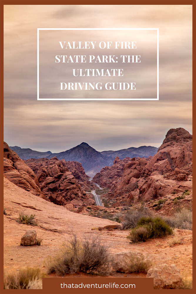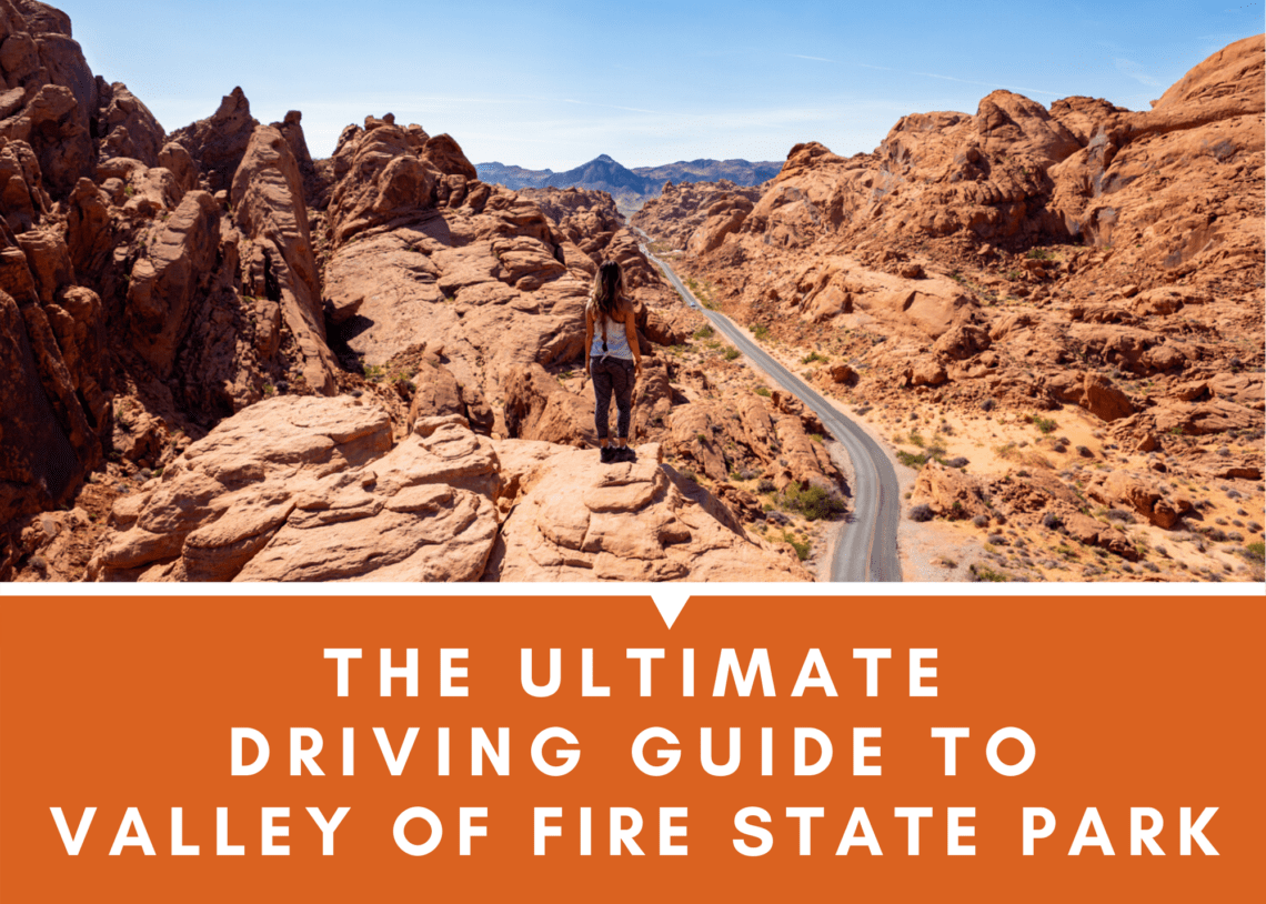
Valley of Fire State Park is a place that you must visit at least once in your life. It is world-renowned for its gorgeous landscape of bright red sandstone outcrops, winding scenic roads, colorful pastel canyons and much more. Depends on what you want to do, you can spend from half a day to a weekend or more here. If you only have a few hours to spend, we put together this ultimate driving guide that will show you the cool places that don’t require a lot of hiking or walking.

Beehives:
Coordinates: 36°24’47.5″N 114°32’53.5″W
Beehives are the first thing you’ll come across if you enter Valley of Fire State Parl from U.S. Route 15. It is the first stop on the right after the entrance. This area gives you a sneak peek of how beautiful this park is. Beehives are these awesome sandstone formations that resemblance giant beehives. They were created by geologic cross-bedding. This means the layers or beds represent different layers of silt that are deposited at different times. The layers indicate the angle of the wind or water was moving at the time the silt was deposited. You can see these movements engraved in the grooves of the beehives. If you have extra time, don’t forget to explore the surrounding area. It is quite beautiful.


Atlatl Rock
Coordinates: 36°25’25.1″N 114°33’02.0″W
Atlatl Rock is located on Campground Road, which is about half a mile down the road from Beehives. This is where you can see up close and personal to petroglyphs that are thousands of years old, on top of a tall platform. The view up there is pretty cool too!


Arch Rock
Coordinates: 36°25’18.5″N 114°33’16.2″W
Arch Rock is a short drive from Atlatl Rock on Campground Road. It is a small arch right off the side of the road. You can walk around to the back of the rock for a better angle. However, since arch rocks are usually very fragile, especially the smaller ones, please don’t climb on it. To be honest, there are way better arch rocks out there, especially if you’ve been to Arches or Joshua Tree National Park. However, it is still nice to visit if you’re in the area.

Fire Cave/Windstone Arch
Coordinates: 36°24’44.9″N 114°33’14.4″W
Fire Cave and Windstone Arch are also located on Campground Road. Campground Road is a loop that will take you back onto the main Valley of Fire Highway. The road turns into an unpaved, washboard road after Arch Rock. It can get very bumpy. This place is my favorite out of all the other stops. Here, you can explore a super cool wind cave called Fire Cave. It’s not hard to find but kind of confusing because there are many other wind caves around. You can see it right off the road if you know where to look. The Windstone Arch is a small arch off in the distance, to the right of the Fire Cave. There are so many other things to explore here. We ran out of time so we didn’t have a chance to really look around. However, we would love to on our next visit.


Seven Sisters
Coordinates: 36°25’35.5″N 114°30’08.2″W
Seven Sisters are yes, you guess it, seven towering red, eroded boulders surround by the sandy desert. At one time, they were a part of the nearby red formations. Because of the relentless forces of erosion, these rock towers are all that remain. This is a good place to stop for a quick lunch or picnics since there are tables and restrooms here.

Elephant Rock
Coordinates: 36°25’41.3″N 114°27’36.7″W
Elephant Rock is one of the most popular rock formations at Valley of Fire State Park. It is the closest to the East Entrance to the park. If you pay attention, you can see Elephant Rock on the side of the road. The coordinates above show where the actual rock is. Parking for this spot is just right before it. Please, do not park on the shoulders. There are trails to take you to the front and behind the formation. The view is definitely better from the back.


Mouse’s Tank Scenic Road
Coordinates: 36°25’43.0″N 114°30’50.2″W
If you’re visiting Valley of Fire State Park, you have to drive through Mouse’s Tank Scenic Road. Not only this scenic road will take you to most of the epic hikes in the park such as the Fire Wave or Pastel/Pink Canyon, but it’s also a breathtaking drive. Mouse’s Tank snakes through bright red narrow canyons, stunning viewpoints, and colorful rocks. It starts at the Visitor Center and ends at White Domes trailhead. This road is only 5.7 miles long.


Rainbow Vista Viewpoint
Coordinates: 36°27’01.3″N 114°30’55.1″W
The view of Mouse’s Tank Scenic Road from here is one of the best in the park. There is a small parking lot right in front. If you want to see the epic views of the Valley of Fire State Park, you’ll have to climb up a 64ft rock formation. This giant rock formation is located right next to the parking lot. It looks sketchy but it is definitely doable. You just have to take your time and be safe. The view from the top here is definitely worth that short climb. If you’re up for some hiking, the trailhead to Rainbow Vista/Fire Canyon Overlook is located right next to the restroom. It is an easy 1.75 mile loop.


Fire Canyon/Silica Dome Overlook
Coordinates: 36°27’20.2″N 114°30’09.3″W
After Rainbow Vista is Fire Canyon Road. This road will take you to Fire Canyon Overlook. The highlight of this area is the distinctive red and white sandstone formations of Fire Canyon and Silica Dome. The color contrast is striking, especially on overcast days.


If you do feel like getting out of the car for a hike you can also check out two of our favorite hikes in the park the Fire Wave Hike and Pastel canyon / Pink Canyon.
You can hear Dustin’s interview about the Valley of Fire State Park on the Between The Mountains Travel Podcast here
Happy Adventuring. Don’t forget to follow us on Instagram, subscribe to our Youtube channel, and sign up for our newsletter!